Title Clearing

What is a Legal Description?

A legal description is the precise location and measurement of real property. While an address is often used to locate a property, legal descriptions are used when transferring title because they’re more accurate. Unlike an address, it’s a unique identifier. It’s especially important when purchasing vacant lots with no address. 


The legal description is referenced during the title search to ensure no encumbrances are on the property before completing the transaction and issuing a title insurance policy. 


The legal description should also give a surveyor enough information to find and measure the land’s boundaries.


Why the Legal Description Matters

The legal description provides accuracy and consistency over time, serves to prevent boundary disputes and problems with chain of title, and facilitates the transfer of ownership. A title insurance policy would be meaningless if you didn’t know what property it insures. The legal description clarifies exactly what parcel of land is conveyed to a new owner. If a boundary dispute arises, the court will reference the legal description to determine if there are any encroachments or easements. 


It also affects how the property is assessed and taxed. 


A legal description is required for: 

  • Public recording 
  • Writing a valid deed of conveyance 
  • Mortgage documents 
  • Executing and recording other real estate documents


While relatively uncommon, a real estate document may contain an inaccurate legal description due to outdated surveying methods. Surveys have become a far more precise science with GPS, drones, and planned community development. 


However, old legal descriptions may be passed from one chain of title documents to another and an incorrect or incomplete description may be conveyed from one unwitting owner to the next. Unplatted vacant properties often present the most prominent challenges related to legal description errors.


Human error when drafting a document or splitting a parcel of land may also cloud the title with an inaccurate legal description. To avoid inheriting an error, buyers should consider conducting a new land survey if one hasn’t been obtained recently. 


If there’s a suspected issue with the legal description, the title company may require a land survey to confirm the legal description is accurate and it closes – meaning the starting point described in the legal description meets with the endpoint. 


Resolving errors with the legal description can delay a real estate closing and cost additional time and money, but ignoring them can jeopardize an owner’s claim to the land.


Where Do You Find a Legal Description?

All the legal documents related to the property and real estate transaction should have the exact same legal description. If any discrepancies are found, it’s a red flag to investigate further. 


Examine the legal description found in these documents: 


  • Deeds
  • Title commitments
  • Surveys 
  • Mortgages
  • Real estate contracts
  • Property tax statements


Look for language like described as, legal, description, or legal description followed by words like lot, block, plat, section, township, range, as well as directional descriptions like north, south, east, and west, and even references to geographical markers like bodies of water.


Searching Public Records

If you want to review the legal description of a property you own or are interested in purchasing but don’t have the deed on hand, you can search the public records. A copy of the deed and other real estate documents known as recording instruments are kept at the recorder’s office where the property is located.


Often, these documents are available to search online. Search by property address, parcel number, or current owner’s name to find the document and the legal description attached. If the deed isn’t available online, you will have to visit the municipal office where it is housed and typically pay a small fee to retrieve a copy. 


Alternatively, you might be able to search the local tax assessor’s online records and examine tax statements containing the legal description. However, not all tax assessors record the complete legal description on the bills, so relying on it for a transaction isn’t the best option. 


Examples of Legal Descriptions

The type of legal description you find on a real estate document depends on factors like the measuring method, the location, and the type of property. 


Common Types of Legal Descriptions

The three types of legal descriptions you’re likely to encounter include: 


  • Metes and bounds 
  • Rectangular Survey System (also known as Public Land Survey System or government survey method)
  • Plat method or lot and block method 


Metes and Bounds

The metes and bounds method is the oldest of the three and was predominantly used by colonial settlers in New England and along the East Coast of the United States. “Metes” means distance and direction, while “bounds” refers to the fixed points like artificial monuments or natural landmarks.


The description reflects the rudimentary tools used to measure the land at the time. You’ll often see references to trees, rocks, bridges, rivers, and other bodies of water. 

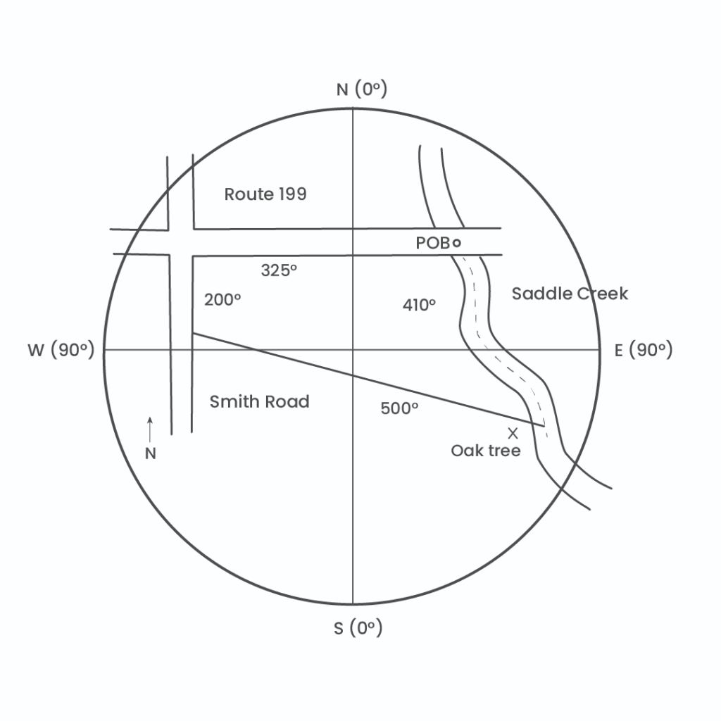
A parcel of land located in Bucks County, Pennsylvania, having the

following description: commencing at the intersection of the south line of

Route 199 and the middle of Saddle Creek, thence southeasterly along the

center thread of Saddle Creek 410 feet, more or less, to the oak tree

landmark, thence north 65 degrees west 500 feet, more or less to the east

line of Smith Road, thence north 2 degrees east 200 feet, more or less,

along the east line of Smith Road to the south line of Route 199, thence

north 90 degrees east 325 feet, more or less, along the south line of

Route 199 to the point of beginning


Rectangular Survey System

This method was adopted in the United States in 1785 to standardize surveying and replace the less accurate metes and bounds method. As the name implies, the system is based on a grid of uniform rectangles or squares using latitude (east and west) and longitude (north and south) lines. Unfortunately, this system doesn’t work well with lots that are shaped irregularly, so metes and bounds or lot and block descriptions are often used in conjunction with the rectangular survey system.


The basic elements of the Rectangular Survey System include: 


  • Meridian: the lines of the grid running north and south. The principal meridian serves as the midpoint dividing the east and west ranges.  
  • Parallel: the lines of the grid running east and west. The principal parallel or baseline divides north and south townships.    
  • Range: the north to south area between two meridians. A range is defined and numbered according to its distance from the principal meridian.  
  • Tier: the east to the west area between two parallels. A tier is defined and numbered according to its distance from the baseline or base parallel. 
  • Township: the area enclosed between two meridians and two parallels, creating a square. Each township has an area of 36 square miles.  
  • Sections: each township is broken up into 36 squares, measuring one mile on each side. 
  • Subsections: each section may be divided further into ½, 1/4, ⅛, 1/16, and so on.    

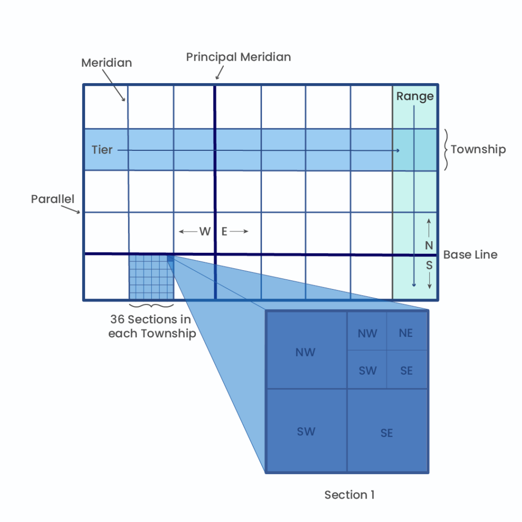
The Northeast corner of Section 1, Township 19, Range 4, Pinellas County, Florida.


Plat or Lot and Block Method

This type of legal description is used in modern planned residential communities, commercial areas, and industrial subdivisions. Tracts of land are subdivided into blocks and then into lots. Within each plat, there is a permanent reference monument or control point that helps determine each property’s location. The surveyor notes the size and location of each lot and block, which is incorporated into the plat of survey or subdivision plat map and recorded in the jurisdiction where the subdivision is located. 


Platted legal descriptions are far more reliable than other types and should rarely require a new survey. 

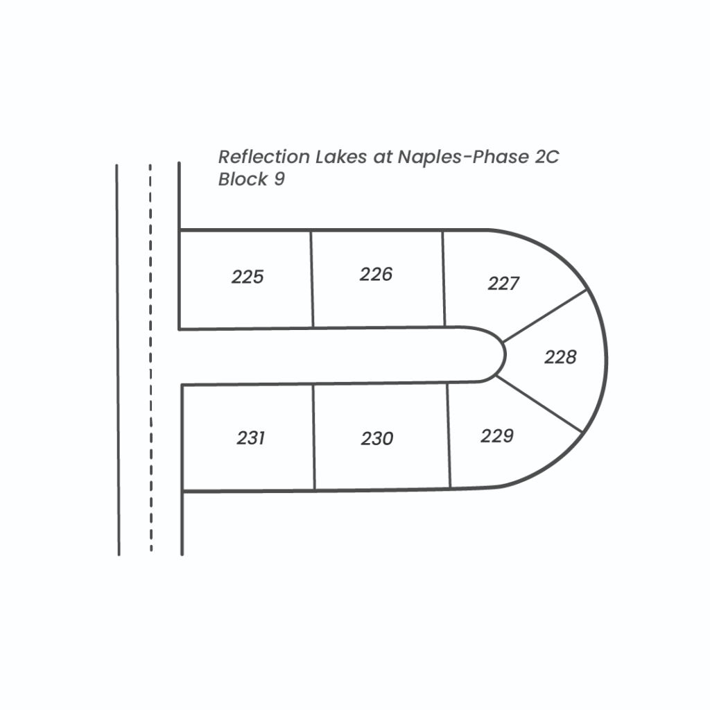
Lot 225, Reflection Lakes at Naples-Phase 2C, a subdivision according to the plat thereof as recorded in Plat Book 46, Page 83, of the Public Records of Collier County, Florida.


Conclusion

Knowing where to find and how to read a legal description is a useful skill for anyone buying property, especially for real estate investors. Protect your investment by requesting a new survey and removing a survey exception from a title policy when appropriate. If you have any questions or concerns about a legal description, turn to your title company or real estate attorney for help. It will take the expertise of professionals to resolve these kinds of errors. At Blueprint, our title professionals have decades of experience clearing title defects. Reach out to our team if you have any questions. 


*The information provided on this site does not, and is not intended to, constitute legal, financial, tax, or real estate advice. Please consult your expert for advice in those areas. All content is for general informational purposes only and is not intended to provide a complete description of the subject matter. Although Blueprint provides information it believes to be accurate, Blueprint makes no representations or warranties about the accuracy or completeness of the information contained on this site. Specific processes will vary based on applicable law. The title and closing process will be handled by a third-party attorney to the extent required by law. Product offerings vary by jurisdiction and are not available or solicited in any state where we are not licensed.